

Teutoburg Forest topographic map
Click on the map to display elevation.
Teutoburg Forest
The highest elevation in the Southern Teutoburg Forest is the Velmerstot (468 m or 1,535 ft) south of Horn-Bad Meinberg. In the Northern Teutoburg Forest the highest elevation is the Dörenberg (331 m or 1,086 ft) north of Bad Iburg.
About this map
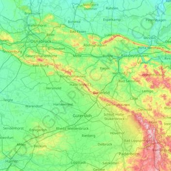
Name: Teutoburg Forest topographic map, elevation, terrain.
Average elevation: 344 ft
Minimum elevation: 102 ft
Maximum elevation: 1,516 ft
Other topographic maps
Click on a map to view its topography, its elevation and its terrain.

Emsquelle
Germany > North Rhine-Westphalia > Kreis Gütersloh > Schloß Holte-Stukenbrock
Average elevation: 443 ft