
Make a donation
Gear up for your next adventure:
As an Amazon Associate, this site earns from qualifying purchases at no extra cost to you.
Vöhringen topographic map
Click on the map to display elevation.
Make a donation
Gear up for your next adventure:
As an Amazon Associate, this site earns from qualifying purchases at no extra cost to you.
About this map
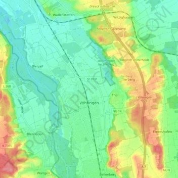
Name: Vöhringen topographic map, elevation, terrain.
Location: Vöhringen, Landkreis Neu-Ulm, Bavaria, 89269, Germany (48.26212 10.03661 48.31477 10.13745)
Average elevation: 1,673 ft
Minimum elevation: 1,578 ft
Maximum elevation: 1,860 ft
Make a donation
Gear up for your next adventure:
As an Amazon Associate, this site earns from qualifying purchases at no extra cost to you.
Other topographic maps
Click on a map to view its topography, its elevation and its terrain.
Kellmünz an der Iller
Germany > Bavaria > Landkreis Neu-Ulm > Kellmünz a.d.Iller
Average elevation: 1,844 ft
Make a donation
Gear up for your next adventure:
As an Amazon Associate, this site earns from qualifying purchases at no extra cost to you.