
Make a donation
Gear up for your next adventure:
As an Amazon Associate, this site earns from qualifying purchases at no extra cost to you.
New City topographic map
Click on the map to display elevation.
Make a donation
Gear up for your next adventure:
As an Amazon Associate, this site earns from qualifying purchases at no extra cost to you.
About this map
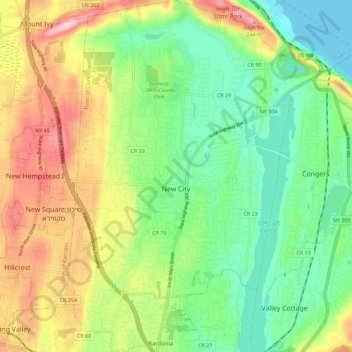
Name: New City topographic map, elevation, terrain.
Average elevation: 292 ft
Minimum elevation: 0 ft
Maximum elevation: 758 ft
Rockland County trails, hiking, mountain biking, running and outdoor activities
Make a donation
Gear up for your next adventure:
As an Amazon Associate, this site earns from qualifying purchases at no extra cost to you.
Other topographic maps
Click on a map to view its topography, its elevation and its terrain.
Evans Park Trail/Woods
United States > New York > Rockland County > Pearl River
Average elevation: 269 ft
Palisades
United States > New York > Rockland County > Palisades > Palisades
Average elevation: 118 ft
Make a donation
Gear up for your next adventure:
As an Amazon Associate, this site earns from qualifying purchases at no extra cost to you.
Tomkins Cove
United States > New York > Rockland County > Town of Stony Point
Average elevation: 223 ft
Make a donation
Gear up for your next adventure:
As an Amazon Associate, this site earns from qualifying purchases at no extra cost to you.
Kings Gate Park
United States > New York > Rockland County > Village of Montebello
Average elevation: 505 ft