
Make a donation
Gear up for your next adventure:
As an Amazon Associate, this site earns from qualifying purchases at no extra cost to you.
Ambae topographic map
Click on the map to display elevation.
Make a donation
Gear up for your next adventure:
As an Amazon Associate, this site earns from qualifying purchases at no extra cost to you.
Ambae
Traditional subsistence agriculture satisfies food needs, while most villagers engage in small-scale cash crop production as well. Often grown in large upland gardens (with good rainfall and safe from roving pigs), the primary crops are taro, banana, yam, and manioc. sweet potatoes, vegetables, fruits and nuts are staples of the local diet, though protein is occasionally lacking. Without substantial reefs, seafood is less significant a protein source compared with other islands of Vanuatu and in any case is inaccessible to the large populations living at high inland elevations.
Make a donation
Gear up for your next adventure:
As an Amazon Associate, this site earns from qualifying purchases at no extra cost to you.
About this map
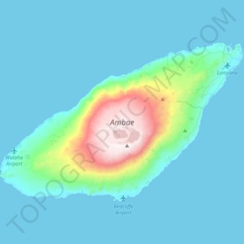
Name: Ambae topographic map, elevation, terrain.
Location: Ambae, Penama, Vanuatu (-15.47597 167.67261 -15.27453 167.99297)
Average elevation: 574 ft
Minimum elevation: 0 ft
Maximum elevation: 4,806 ft
Make a donation
Gear up for your next adventure:
As an Amazon Associate, this site earns from qualifying purchases at no extra cost to you.
Other topographic maps
Click on a map to view its topography, its elevation and its terrain.