
Goyer topographic map
Interactive map
Click on the map to display elevation.
About this map
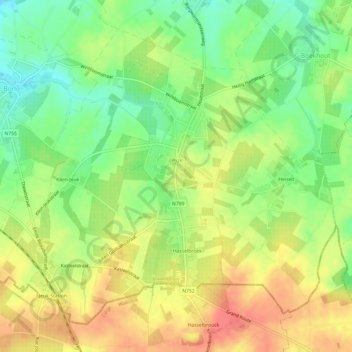
Name: Goyer topographic map, elevation, terrain.
Location: Goyer, Gingelom, Hasselt, Limbourg, Belgique (50.71650 5.17653 50.74863 5.23691)
Average elevation: 367 ft
Minimum elevation: 276 ft
Maximum elevation: 456 ft
Other topographic maps
Click on a map to view its topography, its elevation and its terrain.
Saint-Trond
Belgique > Limbourg > Hasselt > Saint-Trond
Saint-Trond, Hasselt, Limbourg, Flandre, Belgique
Average elevation: 177 ft
Saint-Trond
Saint-Trond, Hasselt, Limbourg, Flandre, Belgique
Average elevation: 190 ft
Diepenbeek
Diepenbeek, Hasselt, Limbourg, 3590, Belgique
Average elevation: 144 ft
Niel-lez-Saint-Trond
Belgique > Limbourg > Hasselt > Niel-lez-Saint-Trond
Niel-lez-Saint-Trond, Gingelom, Hasselt, Limbourg, Flandre, Belgique
Average elevation: 318 ft
Bourg-Léopold
Belgique > Limbourg > Hasselt > Bourg-Léopold
Bourg-Léopold, Hasselt, Limbourg, Flandre, 3970, Belgique
Average elevation: 157 ft