Geolocate

Cartago topographic map

Click on the map to display elevation.

Cartago

It has an elevation of 1,435 m (4,708 ft) above sea level, at the base of the Irazú Volcano.

Wikipedia (CC-BY-SA 3.0)

About this map

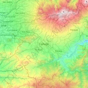
Name: Cartago topographic map, elevation, terrain.

Location: Cartago, Oriental, Cantón Cartago, Cartago Province, 30101, Costa Rica (9.70424 -84.08044 10.02424 -83.76044)

Average elevation: 5,597 ft

Minimum elevation: 2,585 ft

Maximum elevation: 11,220 ft

Gear up for your next adventure:

🥄Camping Utensil Set - Lightweight utensils for outdoor meals
GPS Sports Watch - GPS watch for running, hiking and training
🪶LED Camping Lantern - Bright lantern for camp lighting
📖Nature Tracking Books - Learn to track wildlife and terrain
🎒Waterproof Dry Bags - Keep your electronics and maps dry inside your pack

As an Amazon Associate, this site earns from qualifying purchases at no extra cost to you.