Geolocate

Rainier topographic map

Click on the map to display elevation.

About this map

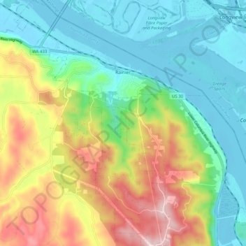
Name: Rainier topographic map, elevation, terrain.

Location: Rainier, Columbia County, Oregon, United States (46.04008 -122.98031 46.10909 -122.90297)

Average elevation: 404 ft

Minimum elevation: -16 ft

Maximum elevation: 1,175 ft

Columbia County trails, hiking, mountain biking, running and outdoor activities

Other topographic maps

Click on a map to view its topography, its elevation and its terrain.

Camp Wilkerson

United States > Oregon > Columbia County

Average elevation: 1,283 ft

Deer Island

United States > Oregon > Columbia County

Average elevation: 151 ft

Inglis

United States > Oregon > Columbia County

Average elevation: 249 ft

Gear up for your next adventure:

🔥Fast-Boil Camping Stoves - Efficient cooking systems for quick trail meals
🔊Portable Camp Speaker - Music and alerts at camp
🧤Hiking Gloves - Protective gloves for rugged trails
📻Weather Alert Radios - Stay informed of storm risks while off-the-grid
🪶Multi‑Purpose Knife - Useful blade for camp and trail

As an Amazon Associate, this site earns from qualifying purchases at no extra cost to you.