
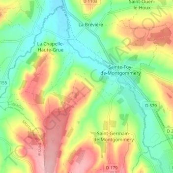
Sainte-Foy-de-Montgommery topographic map
Interactive map
Click on the map to display elevation.
About this map
Name: Sainte-Foy-de-Montgommery topographic map, elevation, terrain.
Average elevation: 436 ft
Minimum elevation: 230 ft
Maximum elevation: 709 ft
Other topographic maps
Click on a map to view its topography, its elevation and its terrain.
La Brévière
France > Normandie > Calvados > Val-de-Vie
La Brévière, Val-de-Vie, Lisieux, Calvados, Normandie, France métropolitaine, 14140, France
Average elevation: 394 ft
La Chapelle-Haute-Grue
France > Normandie > Calvados > Val-de-Vie
La Chapelle-Haute-Grue, Val-de-Vie, Lisieux, Calvados, Normandie, France métropolitaine, 14140, France
Average elevation: 381 ft