
Make a donation
Gear up for your next adventure:
As an Amazon Associate, this site earns from qualifying purchases at no extra cost to you.
Baños topographic map
Click on the map to display elevation.
Make a donation
Gear up for your next adventure:
As an Amazon Associate, this site earns from qualifying purchases at no extra cost to you.
Baños
Baños is located at an elevation of 1,820 metres (5,971 feet) on the northern foothills of the Tungurahua volcano, whose activity has been characterized by frequent powerful ash explosions and lava flows that can be seen from Banos.
Make a donation
Gear up for your next adventure:
As an Amazon Associate, this site earns from qualifying purchases at no extra cost to you.
About this map
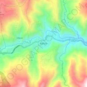
Name: Baños topographic map, elevation, terrain.
Average elevation: 7,759 ft
Minimum elevation: 5,390 ft
Maximum elevation: 11,404 ft
Make a donation
Gear up for your next adventure:
As an Amazon Associate, this site earns from qualifying purchases at no extra cost to you.