
Nebel topographic map
Interactive map
Click on the map to display elevation.
About this map
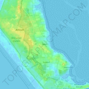
Name: Nebel topographic map, elevation, terrain.
Average elevation: 13 ft
Minimum elevation: -10 ft
Maximum elevation: 66 ft
Other topographic maps
Click on a map to view its topography, its elevation and its terrain.
Neukirchen
Allemagne > Schleswig-Holstein > Nordfriesland
Neukirchen, Südtondern, Nordfriesland, Schleswig-Holstein, 25927, Allemagne
Average elevation: 0 ft
Wenningstedt-Braderup (Sylt)
Allemagne > Schleswig-Holstein > Nordfriesland
Wenningstedt-Braderup (Sylt), Landschaft Sylt, Nordfriesland, Schleswig-Holstein, 25996, Allemagne
Average elevation: 46 ft