
Ucanha topographic map
Interactive map
Click on the map to display elevation.
About this map
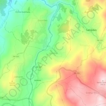
Name: Ucanha topographic map, elevation, terrain.
Location: Ucanha, Tarouca, Viseu, 5110-460, Portugal (41.02577 -7.76445 41.06577 -7.72445)
Average elevation: 1,811 ft
Minimum elevation: 1,125 ft
Maximum elevation: 2,615 ft
Other topographic maps
Click on a map to view its topography, its elevation and its terrain.
Gouviães e Ucanha
Gouviães e Ucanha, Tarouca, Viseu, Portugal
Average elevation: 1,778 ft