
Leyte topographic map
Interactive map
Click on the map to display elevation.
About this map
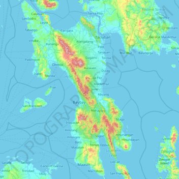
Name: Leyte topographic map, elevation, terrain.
Location: Leyte, Eastern Visayas, Philippines (10.00448 124.28589 11.56351 125.26800)
Average elevation: 223 ft
Minimum elevation: -3 ft
Maximum elevation: 4,062 ft
Other topographic maps
Click on a map to view its topography, its elevation and its terrain.
Patag
Philippines > Leyte > Baybay
Patag, Baybay, Leyte 5th District, Leyte, Eastern Visayas, 6521, Philippines
Average elevation: 210 ft
Gabas
Philippines > Leyte > Baybay > Gabas
Gabas, Baybay, Leyte 5th District, Leyte, Eastern Visayas, 6521, Philippines
Average elevation: 79 ft
Balante
Philippines > Leyte > Balante
Balante, Julita, Leyte 2nd District, Leyte, Eastern Visayas, 6506, Philippines
Average elevation: 125 ft