
Illizi topographic map
Interactive map
Click on the map to display elevation.
About this map
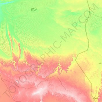
Name: Illizi topographic map, elevation, terrain.
Location: Illizi, Daïra d'Illizi, Illizi, 33000, Algérie (25.14706 6.13964 27.82948 10.03577)
Average elevation: 2,539 ft
Minimum elevation: 1,161 ft
Maximum elevation: 6,683 ft
Other topographic maps
Click on a map to view its topography, its elevation and its terrain.
Sidi Bouslah
Algérie > Illizi > Daïra d'Illizi > Illizi
Sidi Bouslah, Illizi, Daïra d'Illizi, Illizi, 33000, Algérie
Average elevation: 1,827 ft
Oued Souf Mellene
Algérie > Illizi > Daïra d'Illizi > Illizi
Oued Souf Mellene, Illizi, Daïra d'Illizi, Illizi, Algérie
Average elevation: 2,001 ft