
Thank you for supporting this site ❤️
Make a donation
Make a donation
Gear up for your next adventure:
As an Amazon Associate, this site earns from qualifying purchases at no extra cost to you.
Santu Idu/San Vito topographic map
Click on the map to display elevation.
Thank you for supporting this site ❤️
Make a donation
Make a donation
Gear up for your next adventure:
As an Amazon Associate, this site earns from qualifying purchases at no extra cost to you.
About this map
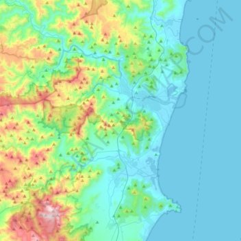
Name: Santu Idu/San Vito topographic map, elevation, terrain.
Location: Santu Idu/San Vito, Cagliari, Sardinia, 09040, Italy (39.26176 9.40966 39.54674 9.60639)
Average elevation: 623 ft
Minimum elevation: -10 ft
Maximum elevation: 3,251 ft
Thank you for supporting this site ❤️
Make a donation
Make a donation
Gear up for your next adventure:
As an Amazon Associate, this site earns from qualifying purchases at no extra cost to you.
Other topographic maps
Click on a map to view its topography, its elevation and its terrain.