
Hof HaCarmel Regional Council topographic map
Interactive map
Click on the map to display elevation.
About this map
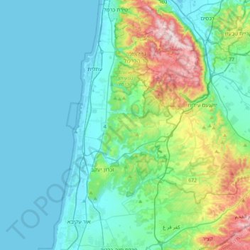
Name: Hof HaCarmel Regional Council topographic map, elevation, terrain.
Location: Hof HaCarmel Regional Council, Haifa District, 30***, Israel (32.48291 34.88672 32.77277 35.05777)
Average elevation: 335 ft
Minimum elevation: -10 ft
Maximum elevation: 1,772 ft
Other topographic maps
Click on a map to view its topography, its elevation and its terrain.
Caesarea
Israel > Haifa District > Hof HaCarmel Regional Council > Caesarea
Caesarea, Hof HaCarmel Regional Council, Hadera Subdistrict, Haifa District, 30***, Israel
Average elevation: 46 ft