Geolocate
👉 Easily get elevation data in JSON, GeoTIFF and KML formats using Elevation API
Thank you for supporting this site ❤️
Make a donation

Fort Worth topographic map

Click on the map to display elevation.

👉 Easily get elevation data in JSON, GeoTIFF and KML formats using Elevation API
Thank you for supporting this site ❤️
Make a donation

About this map

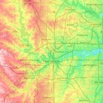
Name: Fort Worth topographic map, elevation, terrain.

Location: Fort Worth, Tarrant County, Texas, United States (32.55158 -97.59239 33.04953 -97.03358)

Average elevation: 696 ft

Minimum elevation: 436 ft

Maximum elevation: 1,093 ft

Tarrant County trails, hiking, mountain biking, running and outdoor activities

Other topographic maps

Click on a map to view its topography, its elevation and its terrain.

Center Point

United States > Texas > Tarrant County

Average elevation: 719 ft

Echo Lake Park

United States > Texas > Tarrant County > Fort Worth

Average elevation: 643 ft

Kimzey Park

United States > Texas > Tarrant County > Colleyville

Average elevation: 607 ft

Bob Eden Park

United States > Texas > Tarrant County > Euless

Average elevation: 568 ft

Risk Lake

United States > Texas > Tarrant County > Fort Worth

Average elevation: 568 ft

Kings Mill

United States > Texas > Tarrant County > Mansfield

Average elevation: 600 ft

Azle

United States > Texas > Tarrant County > Azle

Average elevation: 735 ft

Fort Worth

United States > Texas > Tarrant County > Fort Worth

Average elevation: 663 ft

Boomtown

United States > Texas > Tarrant County > Arlington

Average elevation: 558 ft

Britton Park

United States > Texas > Tarrant County > Mansfield > Britton

Average elevation: 545 ft

Moselle

United States > Texas > Tarrant County > Fort Worth

Average elevation: 764 ft

Bisbee

United States > Texas > Tarrant County > Mansfield

Average elevation: 699 ft

Winscott

United States > Texas > Tarrant County

Average elevation: 919 ft

Mansfield

United States > Texas > Tarrant County

Average elevation: 640 ft

Center Point

United States > Texas > Tarrant County

Average elevation: 719 ft

Peden

United States > Texas > Tarrant County

Average elevation: 725 ft

Southlake

United States > Texas > Tarrant County > Southlake > Southlake

Average elevation: 623 ft

Rendon

United States > Texas > Tarrant County > Fort Worth

Average elevation: 725 ft

Glenwood Park

United States > Texas > Tarrant County > Fort Worth

Average elevation: 587 ft

Gear up for your next adventure:

🧦Hiking Socks - Comfortable socks to prevent blisters on long hikes
🪶Wildlife Field Guides - Learn animal tracking and species ID
🥤Water Filter Bottle - All‑in‑one filter bottle for safe hydration
🧣Merino Neck Gaiters - Multi-functional headwear for wind and sun protection
🎁Geography Themed Gifts - Unique gift ideas for map lovers and geography enthusiasts

As an Amazon Associate, this site earns from qualifying purchases at no extra cost to you.