Geolocate

Ozark topographic map

Click on the map to display elevation.

About this map

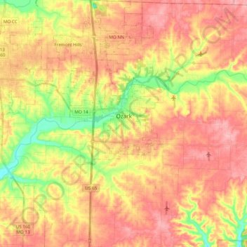
Name: Ozark topographic map, elevation, terrain.

Location: Ozark, Christian County, Missouri, United States (36.93916 -93.25725 37.09266 -93.17497)

Average elevation: 1,276 ft

Minimum elevation: 1,047 ft

Maximum elevation: 1,437 ft

Christian County trails, hiking, mountain biking, running and outdoor activities

Other topographic maps

Click on a map to view its topography, its elevation and its terrain.

Chadwick

United States > Missouri > Christian County

Average elevation: 1,263 ft

Gear up for your next adventure:

📷Action Cameras - Rugged cameras to document your journeys across rugged terrain
🎒Trekking Poles - Sturdy poles for balance and stability on rough terrain
🧭Pro Hiking Compasses - High-accuracy liquid-filled compasses for topographic orientation
🦶Hiking Gaiters - Keep debris and water out of your boots
🔋Solar Power Banks - Keep your GPS and phone charged in remote wilderness areas

As an Amazon Associate, this site earns from qualifying purchases at no extra cost to you.