
Make a donation
Gear up for your next adventure:
As an Amazon Associate, this site earns from qualifying purchases at no extra cost to you.
Kreuzberg topographic map
Click on the map to display elevation.
Make a donation
Gear up for your next adventure:
As an Amazon Associate, this site earns from qualifying purchases at no extra cost to you.
Kreuzberg
In contrast to many other areas of Berlin, which were villages before their integration into Berlin, Kreuzberg has a rather short history. It was formed on 1 October 1920 by the Greater Berlin Act, which provided for the incorporation of suburbs and the reorganisation of Berlin into twenty boroughs. The eastern Friedrichsvorstadt, the southern Friedrichstadt, the western and southern Luisenstadt, and the Tempelhofer Vorstadt were merged into the new sixth borough of Berlin, first named Hallesches Tor. On 27 September 1921, the borough assembly of Hallesches Tor decided to rename the borough after the homonymous hill. Kreuzberg, literally meaning 'cross hill', is the point of the highest elevation in the Kreuzberg locality, which is 66 m (217 ft) above sea level. The hill is traditionally a place for weekend trips. It received its name from the 1821 Prussian National Monument for the Liberation Wars by Karl Friedrich Schinkel within the Viktoriapark, built in commemoration of the Napoleonic Wars. Except for its northernmost part—the quarter Friedrichstadt (established at the end of the 17th century)—today's Kreuzberg was a very rural place until well into the 19th century.
Make a donation
Gear up for your next adventure:
As an Amazon Associate, this site earns from qualifying purchases at no extra cost to you.
About this map
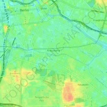
Name: Kreuzberg topographic map, elevation, terrain.
Location: Kreuzberg, Friedrichshain-Kreuzberg, Berlin, Germany (52.48279 13.36823 52.50938 13.45293)
Average elevation: 141 ft
Minimum elevation: 95 ft
Maximum elevation: 220 ft
Make a donation
Gear up for your next adventure:
As an Amazon Associate, this site earns from qualifying purchases at no extra cost to you.
Other topographic maps
Click on a map to view its topography, its elevation and its terrain.
Teufelsberg
Teufelsberg was originally thought to be 115 metres (377 ft) high, which placed it at the same elevation as Großer Müggelberg (the summit of Müggelberge), and was the highest point in West Berlin. New measurements show that Teufelsberg is actually 120.1 metres (394 ft) high, making it higher than Großer…
Average elevation: 177 ft
Viktoriapark
On the occasion of the elevation of the monument ideas appeared to lay out a park around it. Two years later the design of a park was put out to tender. Hermann Mächtig (*1837-1909*), since 1877 Berlin's city garden director, handed in a design, already using the name Victoria Park, in honour of Princess…
Average elevation: 148 ft
Make a donation
Gear up for your next adventure:
As an Amazon Associate, this site earns from qualifying purchases at no extra cost to you.