
Clariden topographic map
Interactive map
Click on the map to display elevation.
About this map
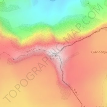
Name: Clariden topographic map, elevation, terrain.
Location: Clariden, Silenen, Uri, Svizzera (46.84189 8.87106 46.84199 8.87116)
Average elevation: 9,065 ft
Minimum elevation: 6,972 ft
Maximum elevation: 10,663 ft
Other topographic maps
Click on a map to view its topography, its elevation and its terrain.
Gross Windgällen
Gross Windgällen, Silenen, Uri, 6475, Svizzera
Average elevation: 7,851 ft
Piz Cazarauls
Piz Cazarauls, Silenen, Uri, Svizzera
Average elevation: 8,806 ft