Geolocate

Garnett topographic map

Click on the map to display elevation.

About this map

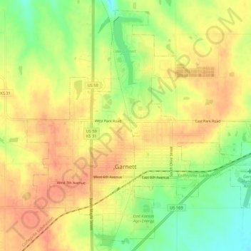
Name: Garnett topographic map, elevation, terrain.

Location: Garnett, Anderson County, Kansas, United States (38.26800 -95.26298 38.30679 -95.20947)

Average elevation: 1,050 ft

Minimum elevation: 951 ft

Maximum elevation: 1,109 ft

Anderson County trails, hiking, mountain biking, running and outdoor activities

Other topographic maps

Click on a map to view its topography, its elevation and its terrain.

Welda

United States > Kansas > Anderson County

Average elevation: 1,112 ft

Gear up for your next adventure:

🎒Trekking Poles - Sturdy poles for balance and stability on rough terrain
🌐World Map Poster - Decorative world maps with topographic info
🛏️Cold Weather Sleeping Bag - Warm sleeping bag for cold conditions
👟Men's Trail Runners - Lightweight footwear for fast-paced exploration and light hiking
🏫Relief Map Kits - Hands-on tools for teaching landforms and elevation

As an Amazon Associate, this site earns from qualifying purchases at no extra cost to you.