
Caldas Novas topographic map
Interactive map
Click on the map to display elevation.
About this map
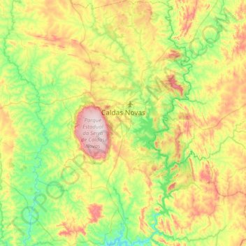
Name: Caldas Novas topographic map, elevation, terrain.
Average elevation: 2,277 ft
Minimum elevation: 1,673 ft
Maximum elevation: 3,432 ft
The most important study about the thermal ism of Caldas Novas and the Rio Quente was carried out by the state enterprise Furnas Centrais Elétricas, due to the possible influence of the Usina Hidrelétrica Corumbá I dam on the thermal water table of the region, which would be under the risk of cooling. According to Furnas, the phenomenon of the hot water is produced by peculiar geological and topographic characteristics. For years it was thought that a volcano had existed in the area in whose crater rainwater infiltrated, heating at great depths and then returning to the surface by way of cracks in the rock. More modern studies show that there is no indication of volcanic activity in the region. Studies show that the water is formed by rainfall that is stored in a layer of quartzite and due to pressure is sent to the surface in a column 600 meters.
Other topographic maps
Click on a map to view its topography, its elevation and its terrain.
São Miguel do Araguaia
São Miguel do Araguaia, Região Geográfica Imediata de Porangatu, Região Geográfica Intermediária de Porangatu-Uruaçu, Goiás, Central-West Region, 76550-000, Brazil
Average elevation: 823 ft
Corumbá de Goiás
Brazil > Goiás > Região Integrada de Desenvolvimento do Distrito Federal e Entorno
Corumbá de Goiás, Região Geográfica Imediata de Anápolis, Região Integrada de Desenvolvimento do Distrito Federal e Entorno, Região Geográfica Intermediária de Goiânia, Goiás, Central-West Region, Brazil
Average elevation: 3,291 ft
Lago Azul
Brazil > Goiás > Região Integrada de Desenvolvimento do Distrito Federal e Entorno > Novo Gama
Lago Azul, Novo Gama, Região Geográfica Imediata de Luziânia, Região Integrada de Desenvolvimento do Distrito Federal e Entorno, Região Geográfica Intermediária de Luziânia-Águas Lindas de Goiás, Goiás, Central-West Region, 72865-105, Brazil
Average elevation: 3,261 ft
Rio Quente
Brazil > Goiás > Rio Quente
Rio Quente, Região Geográfica Imediata de Caldas Novas-Morrinhos, Região Geográfica Intermediária de Itumbiara, Goiás, Central-West Region, Brazil
Average elevation: 2,300 ft
Lagoa Santa
Brazil > Goiás > Lagoa Santa
Lagoa Santa, Microrregião de Quirinópolis, Região Geográfica Intermediária de Rio Verde, Goiás, Central-West Region, Brazil
Average elevation: 1,516 ft
Pirenópolis
Brazil > Goiás > Pirenópolis
Pirenópolis, Microrregião do Entorno de Brasília, Região Integrada de Desenvolvimento do Distrito Federal e Entorno, Mesorregião Leste Goiano, Goiás, Central-West Region, Brazil
Average elevation: 2,897 ft
Cavalcante
Brazil > Goiás > Cavalcante
Cavalcante, Microrregião da Chapada dos Veadeiros, Mesorregião Norte Goiano, Goiás, Central-West Region, Brazil
Average elevation: 2,362 ft
Alto Horizonte
Brazil > Goiás > Alto Horizonte
Alto Horizonte, Microrregião de Porangatu, Mesorregião Norte Goiano, Goiás, Central-West Region, Brazil
Average elevation: 1,276 ft
Cristalina
Brazil > Goiás > Região Integrada de Desenvolvimento do Distrito Federal e Entorno
Cristalina, Região Geográfica Imediata de Luziânia, Região Integrada de Desenvolvimento do Distrito Federal e Entorno, Região Geográfica Intermediária de Luziânia-Águas Lindas de Goiás, Goiás, Central-West Region, 73850-000, Brazil
Average elevation: 2,867 ft
Santa Fé de Goiás
Brazil > Goiás > Santa Fé de Goiás
Santa Fé de Goiás, Região Geográfica Intermediária de Goiânia, Goiás, Central-West Region, 76265000, Brazil
Average elevation: 1,076 ft
Aparecida de Goiânia
Aparecida de Goiânia, Região Geográfica Imediata de Goiânia, Região Geográfica Intermediária de Goiânia, Goiás, Central-West Region, Brazil
Average elevation: 2,569 ft