
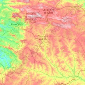
Corumbá de Goiás topographic map
Interactive map
Click on the map to display elevation.
About this map
Name: Corumbá de Goiás topographic map, elevation, terrain.
Average elevation: 3,291 ft
Minimum elevation: 2,221 ft
Maximum elevation: 4,455 ft
Due to variations in elevation, temperatures are quite varied. The average is around 26 °C; The rains obey a tropical pattern and are at their strongest in the period of October to March.
Other topographic maps
Click on a map to view its topography, its elevation and its terrain.
Lago Azul
Brazil > Goiás > Região Integrada de Desenvolvimento do Distrito Federal e Entorno > Novo Gama
Lago Azul, Novo Gama, Região Geográfica Imediata de Luziânia, Região Integrada de Desenvolvimento do Distrito Federal e Entorno, Região Geográfica Intermediária de Luziânia-Águas Lindas de Goiás, Goiás, Central-West Region, 72865-105, Brazil
Average elevation: 3,261 ft
Cristalina
Brazil > Goiás > Região Integrada de Desenvolvimento do Distrito Federal e Entorno
Cristalina, Região Geográfica Imediata de Luziânia, Região Integrada de Desenvolvimento do Distrito Federal e Entorno, Região Geográfica Intermediária de Luziânia-Águas Lindas de Goiás, Goiás, Central-West Region, 73850-000, Brazil
Average elevation: 2,867 ft