
Hunting Ridge topographic map
Interactive map
Click on the map to display elevation.
About this map
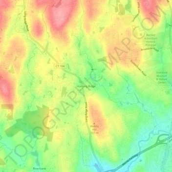
Name: Hunting Ridge topographic map, elevation, terrain.
Average elevation: 266 ft
Minimum elevation: 92 ft
Maximum elevation: 430 ft
Other topographic maps
Click on a map to view its topography, its elevation and its terrain.
Belltown
United States > Connecticut > Western Connecticut Planning Region > Stamford
Belltown, Stamford, Western Connecticut Planning Region, Connecticut, 06906, United States
Average elevation: 105 ft
Palmers Hill
United States > Connecticut > Western Connecticut Planning Region > Stamford
Palmers Hill, Stamford, Western Connecticut Planning Region, Connecticut, 06904, United States
Average elevation: 102 ft
North Stamford
United States > Connecticut > Western Connecticut Planning Region > Stamford
North Stamford, Stamford, Western Connecticut Planning Region, Connecticut, 06903, United States
Average elevation: 292 ft