
Clarksville topographic map
Interactive map
Click on the map to display elevation.
About this map
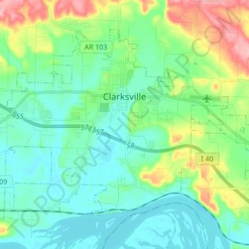
Name: Clarksville topographic map, elevation, terrain.
Location: Clarksville, Johnson County, Arkansas, 72830, United States (35.42239 -93.53741 35.49780 -93.41600)
Average elevation: 449 ft
Minimum elevation: 335 ft
Maximum elevation: 781 ft
Spadra was the first county seat of Johnson County, convenient to steamboat lines. However when stagecoach and train transportation became more common, land routes from Little Rock to Fort Smith were directed along higher elevations through Clarksville. As Clarksville grew, it became the de facto location for the county seat circa 1833, probably due to severe flooding at Spadra. Clarksville was established by survey in November 1836 after Johnson County was formed from part of Pope County. The first court session was held in 1837 in a private building.
Other topographic maps
Click on a map to view its topography, its elevation and its terrain.
Coal Hill
United States > Arkansas > Johnson County
Coal Hill, Johnson County, Arkansas, 72832, United States
Average elevation: 535 ft
Montana
United States > Arkansas > Johnson County
Montana, Johnson County, Arkansas, United States
Average elevation: 410 ft
Harmony
United States > Arkansas > Johnson County
Harmony, Johnson County, Arkansas, United States
Average elevation: 676 ft
Knoxville
United States > Arkansas > Johnson County
Knoxville, Johnson County, Arkansas, 72845, United States
Average elevation: 420 ft
Sulphur Springs
United States > Arkansas > Johnson County
Sulphur Springs, Johnson County, Arkansas, United States
Average elevation: 535 ft
Hickeytown
United States > Arkansas > Johnson County
Hickeytown, Johnson County, Arkansas, United States
Average elevation: 459 ft
Gillian Settlement
United States > Arkansas > Johnson County
Gillian Settlement, Johnson County, Arkansas, United States
Average elevation: 1,578 ft
Oark
United States > Arkansas > Johnson County
Oark, Johnson County, Arkansas, United States
Average elevation: 1,276 ft
Hagarville
United States > Arkansas > Johnson County
Hagarville, Johnson County, Arkansas, United States
Average elevation: 568 ft
Hartman
United States > Arkansas > Johnson County
Hartman, Johnson County, Arkansas, United States
Average elevation: 413 ft
Lake Dardanelle
United States > Arkansas > Johnson County > Knoxville
Lake Dardanelle, Knoxville, Johnson County, Arkansas, 72845, United States
Average elevation: 577 ft
Lamar
United States > Arkansas > Johnson County
Lamar, Johnson County, Arkansas, United States
Average elevation: 456 ft
Ozone
United States > Arkansas > Johnson County
Ozone, Johnson County, Arkansas, 72854, United States
Average elevation: 1,762 ft
Strawberry
United States > Arkansas > Johnson County
Strawberry, Johnson County, Arkansas, United States
Average elevation: 804 ft