
Make a donation
Gear up for your next adventure:
As an Amazon Associate, this site earns from qualifying purchases at no extra cost to you.
Mount Halcon topographic map
Click on the map to display elevation.
Make a donation
Gear up for your next adventure:
As an Amazon Associate, this site earns from qualifying purchases at no extra cost to you.
Mount Halcon
Mount Halcon (Filipino: Bundok Halcon) and (Spanish: Monte Halcón) is the highest mountain in the island of Mindoro in the Philippines, according to the new data release by Oriental Mindoro peakvisor as of 2022, it has an elevation of 2,616 metres (8,583 ft) above sea level, higher than the previous estimates data at 2,586 m (8,484 ft). It is the 23rd-highest peak in the Philippines and 37th-highest peak of an island on Earth. Its steep slopes have earned it the reputation of being one of the most difficult and technically most challenging mountains to climb in the Philippines. The first documented ascent was made in 1906 by American botanist Elmer Drew Merrill and a party of forestry and military personnel.
Make a donation
Gear up for your next adventure:
As an Amazon Associate, this site earns from qualifying purchases at no extra cost to you.
About this map
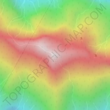
Name: Mount Halcon topographic map, elevation, terrain.
Location: Mount Halcon, Oriental Mindoro, Mimaropa, Philippines (13.26233 120.99554 13.26243 120.99564)
Average elevation: 6,959 ft
Minimum elevation: 5,256 ft
Maximum elevation: 8,376 ft
Make a donation
Gear up for your next adventure:
As an Amazon Associate, this site earns from qualifying purchases at no extra cost to you.
Other topographic maps
Click on a map to view its topography, its elevation and its terrain.
Make a donation
Gear up for your next adventure:
As an Amazon Associate, this site earns from qualifying purchases at no extra cost to you.