
Thank you for supporting this site ❤️
Make a donation
Make a donation
Gear up for your next adventure:
As an Amazon Associate, this site earns from qualifying purchases at no extra cost to you.
Juriquilla topographic map
Click on the map to display elevation.
Thank you for supporting this site ❤️
Make a donation
Make a donation
Gear up for your next adventure:
As an Amazon Associate, this site earns from qualifying purchases at no extra cost to you.
About this map
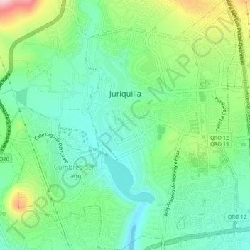
Name: Juriquilla topographic map, elevation, terrain.
Location: Juriquilla, Municipio de Querétaro, Querétaro, Mexico (20.68816 -100.47800 20.72704 -100.43974)
Average elevation: 6,312 ft
Minimum elevation: 6,083 ft
Maximum elevation: 6,821 ft
Thank you for supporting this site ❤️
Make a donation
Make a donation
Gear up for your next adventure:
As an Amazon Associate, this site earns from qualifying purchases at no extra cost to you.
Other topographic maps
Click on a map to view its topography, its elevation and its terrain.
Parque Queretaro 2000
Mexico > Querétaro > Municipio de Querétaro > Querétaro
Average elevation: 6,079 ft