
Plage de Boussekour topographic map
Interactive map
Click on the map to display elevation.
About this map
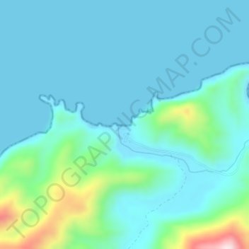
Name: Plage de Boussekour topographic map, elevation, terrain.
Average elevation: 197 ft
Minimum elevation: 0 ft
Maximum elevation: 1,227 ft
Other topographic maps
Click on a map to view its topography, its elevation and its terrain.
Tanda Ifrane
Maroc > Cercle de Bni Ouaryaghel > Izemmouren > Tanda Ifrane
Tanda Ifrane, Izemmouren, caïdat d’Izemmouren, Cercle de Bni Ouaryaghel, Province d'Al Hoceima, Tanger-Tétouan-Al Hoceima, Maroc
Average elevation: 876 ft