Geolocate

Zapotlanejo topographic map

Click on the map to display elevation.

About this map

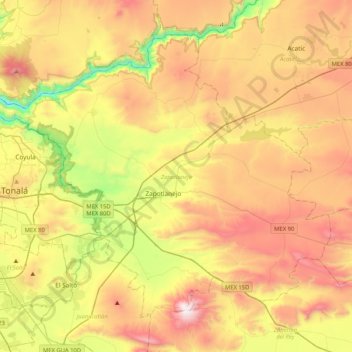
Name: Zapotlanejo topographic map, elevation, terrain.

Location: Zapotlanejo, Jalisco, Mexico (20.48324 -103.28366 20.79617 -102.86943)

Average elevation: 5,407 ft

Minimum elevation: 3,363 ft

Maximum elevation: 7,615 ft

Other topographic maps

Click on a map to view its topography, its elevation and its terrain.

La Laja

Mexico > Jalisco > Zapotlanejo

Average elevation: 4,803 ft

Gear up for your next adventure:

🧣Merino Neck Gaiters - Multi-functional headwear for wind and sun protection
🧥Waterproof Jacket for Hiking - Breathable and rugged rain jacket for outdoor excursions
🏥Hiking First Aid Kits - Comprehensive medical kits for remote trail injuries
🪶Multi‑Purpose Knife - Useful blade for camp and trail
🪶Wildlife Field Guides - Learn animal tracking and species ID

As an Amazon Associate, this site earns from qualifying purchases at no extra cost to you.