Geolocate

Fairlands topographic map

Click on the map to display elevation.

👉 Easily get elevation data in JSON, GeoTIFF and KML formats using Elevation API
Thank you for supporting this site ❤️
Make a donation

About this map

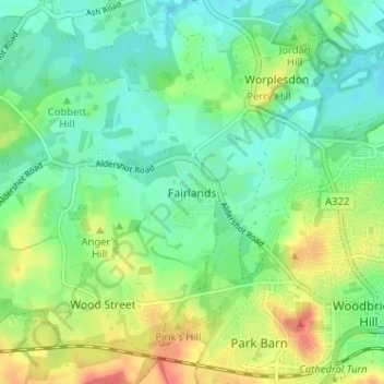
Name: Fairlands topographic map, elevation, terrain.

Location: Fairlands, Guildford, Surrey, England, GU3 3JH, United Kingdom (51.24190 -0.63993 51.28190 -0.59993)

Average elevation: 157 ft

Minimum elevation: 95 ft

Maximum elevation: 272 ft

Other topographic maps

Click on a map to view its topography, its elevation and its terrain.

Effingham

United Kingdom > England > Surrey > Guildford

Average elevation: 344 ft

East Horsley

United Kingdom > England > Surrey > Guildford > East Horsley

Average elevation: 292 ft

Ockham

United Kingdom > England > Surrey > Guildford > Ockham

Average elevation: 125 ft

Send

United Kingdom > England > Surrey > Guildford > Send

Average elevation: 105 ft

Gear up for your next adventure:

🪶Compact Camp Shovel - Folding shovel for campsite tasks
🪵Folding Camp Saw - Compact saw for wood and campsite work
🔦Compact Flashlight - Reliable flashlight for emergencies
🔌Solar Panel Charger - Charge gear sustainably outdoors
👟Men's Trail Runners - Lightweight footwear for fast-paced exploration and light hiking

As an Amazon Associate, this site earns from qualifying purchases at no extra cost to you.