
Make a donation
Gear up for your next adventure:
As an Amazon Associate, this site earns from qualifying purchases at no extra cost to you.
Butte topographic map
Click on the map to display elevation.
Make a donation
Gear up for your next adventure:
As an Amazon Associate, this site earns from qualifying purchases at no extra cost to you.
Butte
Butte's South district, situated at a lower elevation below the hillside that comprises northern Butte, has historically been home to working-class neighborhoods. Gold mines originally populated south Butte before it was platted for the Union Pacific Railroad in 1881.
Make a donation
Gear up for your next adventure:
As an Amazon Associate, this site earns from qualifying purchases at no extra cost to you.
About this map
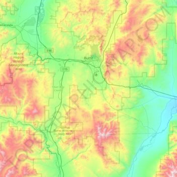
Name: Butte topographic map, elevation, terrain.
Location: Butte, Silver Bow County, Montana, United States (45.62485 -113.08554 46.18547 -112.19004)
Average elevation: 6,263 ft
Minimum elevation: 4,337 ft
Maximum elevation: 10,417 ft
Silver Bow County trails, hiking, mountain biking, running and outdoor activities
Make a donation
Gear up for your next adventure:
As an Amazon Associate, this site earns from qualifying purchases at no extra cost to you.
Other topographic maps
Click on a map to view its topography, its elevation and its terrain.
Homestake Pass
United States > Montana > Silver Bow County > Butte > Highview
Average elevation: 6,388 ft
Make a donation
Gear up for your next adventure:
As an Amazon Associate, this site earns from qualifying purchases at no extra cost to you.