
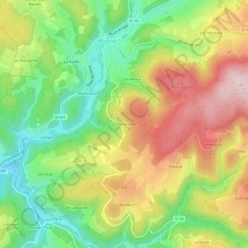
La Rimandière topographic map
Interactive map
Click on the map to display elevation.
About this map
Name: La Rimandière topographic map, elevation, terrain.
Average elevation: 3,104 ft
Minimum elevation: 2,592 ft
Maximum elevation: 3,701 ft
Other topographic maps
Click on a map to view its topography, its elevation and its terrain.
Les Mazeaux
France > Auvergne-Rhône-Alpes > Haute-Loire > Riotord
Les Mazeaux, Riotord, Yssingeaux, Haute-Loire, Auvergne-Rhône-Alpes, France métropolitaine, 43220, France
Average elevation: 3,278 ft
L'Aulagnier
France > Auvergne-Rhône-Alpes > Haute-Loire > Riotord
L'Aulagnier, Riotord, Yssingeaux, Haute-Loire, Auvergne-Rhône-Alpes, France métropolitaine, 43220, France
Average elevation: 3,130 ft
Les Sétoux
France > Auvergne-Rhône-Alpes > Haute-Loire > Riotord
Les Sétoux, Riotord, Yssingeaux, Haute-Loire, Auvergne-Rhône-Alpes, France métropolitaine, 43220, France
Average elevation: 3,757 ft
Les Rivaux
France > Auvergne-Rhône-Alpes > Haute-Loire > Riotord
Les Rivaux, Riotord, Yssingeaux, Haute-Loire, Auvergne-Rhône-Alpes, France métropolitaine, 43220, France
Average elevation: 3,120 ft
Le Collet
France > Auvergne-Rhône-Alpes > Haute-Loire > Riotord
Le Collet, Riotord, Yssingeaux, Haute-Loire, Auvergne-Rhône-Alpes, France métropolitaine, 43220, France
Average elevation: 3,068 ft