
Parroquia Salango topographic map
Interactive map
Click on the map to display elevation.
About this map
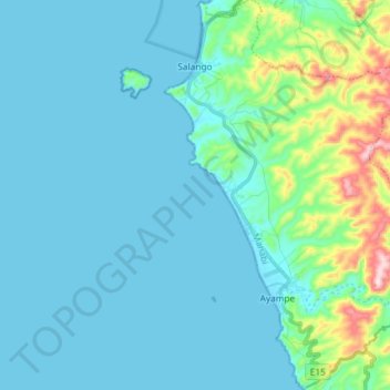
Name: Parroquia Salango topographic map, elevation, terrain.
Location: Parroquia Salango, Puerto López, Manabí, 131950, Ecuador (-1.71170 -80.87125 -1.56580 -80.75371)
Average elevation: 180 ft
Minimum elevation: 0 ft
Maximum elevation: 1,302 ft
Other topographic maps
Click on a map to view its topography, its elevation and its terrain.
Las Tunas
Ecuador > Manabí > Puerto López > Parroquia Salango
Las Tunas, Parroquia Salango, Puerto López, Manabí, 131950, Ecuador
Average elevation: 121 ft