Geolocate

Wendell topographic map

Click on the map to display elevation.

About this map

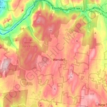
Name: Wendell topographic map, elevation, terrain.

Location: Wendell, Franklin County, Massachusetts, United States (42.50135 -72.46613 42.60788 -72.35378)

Average elevation: 919 ft

Minimum elevation: 308 ft

Maximum elevation: 1,388 ft

Franklin County trails, hiking, mountain biking, running and outdoor activities

Other topographic maps

Click on a map to view its topography, its elevation and its terrain.

Fort Lucas

United States > Massachusetts > Franklin County

Average elevation: 876 ft

Mount Hermon

United States > Massachusetts > Franklin County > Gill

Average elevation: 325 ft

Mount Ram

United States > Massachusetts > Franklin County

Average elevation: 577 ft

Pitt Hill

United States > Massachusetts > Franklin County > Orange

Average elevation: 955 ft

Shelburne

United States > Massachusetts > Franklin County

Average elevation: 873 ft

Mount Hermon

United States > Massachusetts > Franklin County > Gill

Average elevation: 325 ft

Gear up for your next adventure:

🎒Hydration Pack - Hands‑free water reservoir for long hikes
📖Nature Tracking Books - Learn to track wildlife and terrain
Solar GPS Watches - Advanced multisport watches with built-in topographic maps
🏕️Tent Footprint - Protect your tent base from wear
🧼Biodegradable Camping Soap - Eco‑friendly soap for outdoor hygiene

As an Amazon Associate, this site earns from qualifying purchases at no extra cost to you.