Geolocate

Owasso topographic map

Click on the map to display elevation.

About this map

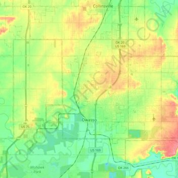
Name: Owasso topographic map, elevation, terrain.

Location: Owasso, Tulsa County, Oklahoma, 74055, United States (36.24886 -95.90201 36.33668 -95.70774)

Average elevation: 653 ft

Minimum elevation: 535 ft

Maximum elevation: 820 ft

Tulsa County trails, hiking, mountain biking, running and outdoor activities

Other topographic maps

Click on a map to view its topography, its elevation and its terrain.

Haikey Creek

United States > Oklahoma > Tulsa County > Broken Arrow

Average elevation: 666 ft

Turley

United States > Oklahoma > Tulsa County

Average elevation: 676 ft

Gear up for your next adventure:

📷Action Cameras - Rugged cameras to document your journeys across rugged terrain
🏕️Tent Footprint - Protect your tent base from wear
👖Convertible Hiking Pants - Versatile zip-off pants for changing altitudes and temperatures
🔋Solar Power Banks - Keep your GPS and phone charged in remote wilderness areas
🔭Stargazing Telescopes - Perfect for camping in low-light pollution areas shown on maps

As an Amazon Associate, this site earns from qualifying purchases at no extra cost to you.