Geolocate

Támesis topographic map

Click on the map to display elevation.

Támesis

Támesis is a town and municipality in the Colombian department of Antioquia. Part of the subregion of Southwestern Antioquia. Located at an elevation of 1,638 m (5,374 ft) above sea level, it was established in 1858. The local economy is based on agriculture.

Wikipedia (CC-BY-SA 3.0)

About this map

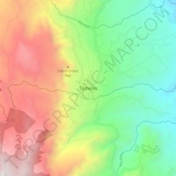
Name: Támesis topographic map, elevation, terrain.

Location: Támesis, Suroeste, Antioquia, RAP del Agua y la Montaña, Colombia (5.62525 -75.75399 5.70525 -75.67399)

Average elevation: 5,636 ft

Minimum elevation: 2,552 ft

Maximum elevation: 9,961 ft

Gear up for your next adventure:

🦟Ultrasonic Repellers - Create a bug-free zone at your camp or rest stop
🧢Outdoor Hiking Hat - Sun protection hat for outdoor explorers
🛰️Satellite Messengers - Emergency SOS and two-way messaging for off-grid adventures
🔦Compact Flashlight - Reliable flashlight for emergencies
🛡️Bear Spray Outdoor - Protection in bear country hikes

As an Amazon Associate, this site earns from qualifying purchases at no extra cost to you.