Geolocate

Sunbury topographic map

Click on the map to display elevation.

About this map

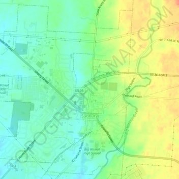
Name: Sunbury topographic map, elevation, terrain.

Location: Sunbury, Delaware County, Ohio, United States (40.23056 -82.89040 40.26516 -82.84272)

Average elevation: 984 ft

Minimum elevation: 925 ft

Maximum elevation: 1,066 ft

Delaware County trails, hiking, mountain biking, running and outdoor activities

Other topographic maps

Click on a map to view its topography, its elevation and its terrain.

Radnor

United States > Ohio > Delaware County

Average elevation: 932 ft

Kilbourne

United States > Ohio > Delaware County

Average elevation: 948 ft

Scioto

United States > Ohio > Delaware County > Scioto

Average elevation: 925 ft

Berkshire

United States > Ohio > Delaware County

Average elevation: 958 ft

Center Green Park

United States > Ohio > Delaware County > Maxtown

Average elevation: 909 ft

Gear up for your next adventure:

🦟Ultrasonic Repellers - Create a bug-free zone at your camp or rest stop
🎒Trekking Poles - Sturdy poles for balance and stability on rough terrain
🪶Survival Guide Book - Expert advice for emergency preparedness
🔪Outdoor Multitools - Essential survival tools for gear repair and field use
🪶Camp Gear Gift Set - Perfect gift bundle for outdoor fans

As an Amazon Associate, this site earns from qualifying purchases at no extra cost to you.