Geolocate

Cairo topographic map

Click on the map to display elevation.

About this map

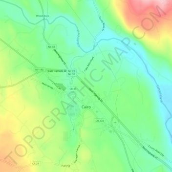
Name: Cairo topographic map, elevation, terrain.

Location: Cairo, Greene County, New York, 12413, United States (42.28264 -74.03738 42.32562 -73.97955)

Average elevation: 443 ft

Minimum elevation: 217 ft

Maximum elevation: 758 ft

Greene County trails, hiking, mountain biking, running and outdoor activities

Gear up for your next adventure:

📷Action Cameras - Rugged cameras to document your journeys across rugged terrain
🌧️Backpack Rain Cover - Keep gear dry in wet weather
🥾Men's Hiking Boots - Durable, waterproof footwear for rugged terrain and steep inclines
🧭Orienteering Set - Complete compass and map reading kit
🛰️Satellite Messengers - Emergency SOS and two-way messaging for off-grid adventures

As an Amazon Associate, this site earns from qualifying purchases at no extra cost to you.