
Njombe topographic map
Interactive map
Click on the map to display elevation.
About this map
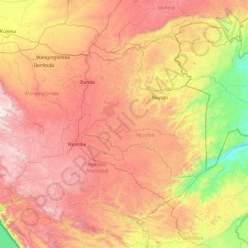
Name: Njombe topographic map, elevation, terrain.
Location: Njombe, Southern Highlands Zone, Tanzanie (-9.64961 34.75383 -8.92275 35.52397)
Average elevation: 4,698 ft
Minimum elevation: 1,243 ft
Maximum elevation: 7,205 ft
Other topographic maps
Click on a map to view its topography, its elevation and its terrain.