
N'Goussa topographic map
Interactive map
Click on the map to display elevation.
About this map
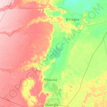
Name: N'Goussa topographic map, elevation, terrain.
Location: N'Goussa, Daïra N'Goussa, Ouargla, 30000, Algérie (32.07579 4.78118 32.61345 5.76949)
Average elevation: 568 ft
Minimum elevation: 299 ft
Maximum elevation: 968 ft
Other topographic maps
Click on a map to view its topography, its elevation and its terrain.
Frane
Algérie > Ouargla > Daïra N'Goussa > N'Goussa
Frane, N'Goussa, Daïra N'Goussa, Ouargla, Algérie
Average elevation: 417 ft