
Bad Vigaun topographic map
Interactive map
Click on the map to display elevation.
About this map
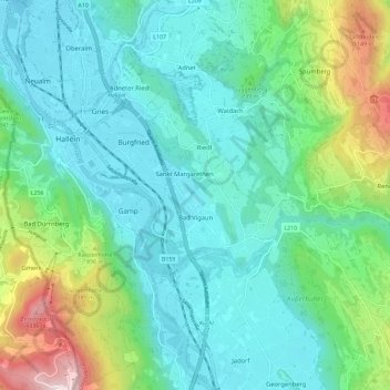
Name: Bad Vigaun topographic map, elevation, terrain.
Location: Bad Vigaun, Bezirk Hallein, Salzburg, 5424, Österreich (47.65445 13.11637 47.68735 13.23155)
Average elevation: 2,146 ft
Minimum elevation: 1,404 ft
Maximum elevation: 4,724 ft
Other topographic maps
Click on a map to view its topography, its elevation and its terrain.
Bad Dürrnberg
Österreich > Salzburg > Bezirk Hallein > Hallein
Bad Dürrnberg, Hallein, Bezirk Hallein, Salzburg, 5400, Österreich
Average elevation: 2,408 ft
Puch bei Hallein
Österreich > Salzburg > Bezirk Hallein
Puch bei Hallein, Bezirk Hallein, Salzburg, 5412, Österreich
Average elevation: 1,811 ft
Adnet
Österreich > Salzburg > Bezirk Hallein
Adnet, Bezirk Hallein, Salzburg, 5421, Österreich
Average elevation: 2,172 ft
Hallein
Österreich > Salzburg > Bezirk Hallein
Hallein, Bezirk Hallein, Salzburg, 5400, Österreich
Average elevation: 2,070 ft
Pass Lueg
Österreich > Salzburg > Bezirk Hallein > Golling an der Salzach
Pass Lueg, Golling an der Salzach, Bezirk Hallein, Salzburg, 5440, Österreich
Average elevation: 2,388 ft