
Thank you for supporting this site ❤️
Make a donation
Make a donation
Gear up for your next adventure:
As an Amazon Associate, this site earns from qualifying purchases at no extra cost to you.
葭町 topographic map
Click on the map to display elevation.
Thank you for supporting this site ❤️
Make a donation
Make a donation
Gear up for your next adventure:
As an Amazon Associate, this site earns from qualifying purchases at no extra cost to you.
About this map
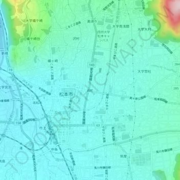
Name: 葭町 topographic map, elevation, terrain.
Location: 葭町, Matsumoto, Nagano Prefecture, 390-0874, Japan (36.21896 137.95533 36.25896 137.99533)
Average elevation: 2,021 ft
Minimum elevation: 1,854 ft
Maximum elevation: 2,943 ft
Thank you for supporting this site ❤️
Make a donation
Make a donation
Gear up for your next adventure:
As an Amazon Associate, this site earns from qualifying purchases at no extra cost to you.