Geolocate

Baghdad topographic map

Click on the map to display elevation.

About this map
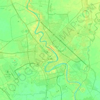
Name: Baghdad topographic map, elevation, terrain.

Location: Baghdad, Green Zone Municipality, Zawra District, Baghdad Governorate, Iraq (33.17976 44.18462 33.48683 44.57000)

Average elevation: 118 ft

Minimum elevation: 85 ft

Maximum elevation: 184 ft

Other topographic maps

Click on a map to view its topography, its elevation and its terrain.
Tall Zuaitit

Iraq > Baghdad Governorate

Average elevation: 128 ft

Sippar

Iraq > Baghdad Governorate > Al Yusufiyah

Average elevation: 121 ft

Al saha

Iraq > Baghdad Governorate > Baghdad

Average elevation: 115 ft

Ahwiz

Iraq > Baghdad Governorate

Average elevation: 131 ft

An Nil

Iraq > Baghdad Governorate > Baghdad > An Nil

Average elevation: 121 ft

Al Idrisi

Iraq > Baghdad Governorate > Baghdad > Al Idrisi

Average elevation: 121 ft

Gear up for your next adventure:

🌄Hiking Binoculars - Compact binoculars for scenic views and trail spotting
🔥Plasma Lighters - Windproof lighters that work in any weather condition
🔭Compact Binoculars - HD vision for scouting terrain and identifying distant landmarks
🔦LED Headlamp - Bright and durable LED headlamp for night navigation
🦺Reflective Outdoor Gear - Safety gear for low‑light conditions

As an Amazon Associate, this site earns from qualifying purchases at no extra cost to you.