
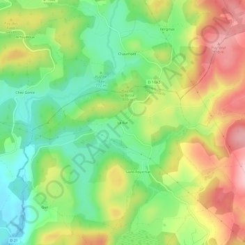
Le Rat topographic map
Interactive map
Click on the map to display elevation.
About this map
Name: Le Rat topographic map, elevation, terrain.
Average elevation: 2,618 ft
Minimum elevation: 2,346 ft
Maximum elevation: 2,969 ft
Other topographic maps
Click on a map to view its topography, its elevation and its terrain.
Chamboux
France > Nouvelle-Aquitaine > Corrèze > Peyrelevade
Chamboux, Peyrelevade, Ussel, Corrèze, Nouvelle-Aquitaine, France métropolitaine, 19290, France
Average elevation: 2,602 ft
Lac de Servières
France > Nouvelle-Aquitaine > Corrèze > Peyrelevade > Servières
Lac de Servières, Servières, Peyrelevade, Ussel, Corrèze, Nouvelle-Aquitaine, France métropolitaine, 19290, France
Average elevation: 2,487 ft
Geneyte
France > Nouvelle-Aquitaine > Corrèze > Peyrelevade
Geneyte, Peyrelevade, Ussel, Corrèze, Nouvelle-Aquitaine, France métropolitaine, 19290, France
Average elevation: 2,530 ft
La Moutade
France > Nouvelle-Aquitaine > Corrèze > Peyrelevade
La Moutade, Peyrelevade, Ussel, Corrèze, Nouvelle-Aquitaine, France métropolitaine, 19290, France
Average elevation: 2,631 ft