
Villar del Arzobispo topographic map
Interactive map
Click on the map to display elevation.
About this map
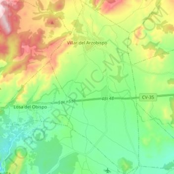
Name: Villar del Arzobispo topographic map, elevation, terrain.
Average elevation: 1,562 ft
Minimum elevation: 827 ft
Maximum elevation: 3,035 ft
Other topographic maps
Click on a map to view its topography, its elevation and its terrain.
Pedralba
Spain > Valencian Community > La Serranía
Pedralba, La Serranía, Valencia, Valencian Community, 46164, Spain
Average elevation: 791 ft
Calles
Spain > Valencian Community > La Serranía
Calles, La Serranía, Valencia, Valencian Community, Spain
Average elevation: 2,221 ft