
Kirklees topographic map
Interactive map
Click on the map to display elevation.
About this map
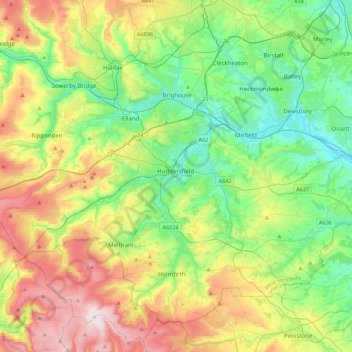
Name: Kirklees topographic map, elevation, terrain.
Average elevation: 722 ft
Minimum elevation: 92 ft
Maximum elevation: 1,906 ft
Other topographic maps
Click on a map to view its topography, its elevation and its terrain.
Lindley
United Kingdom > England > Kirklees
Lindley, Kirklees, West Yorkshire, England, HD3 3LZ, United Kingdom
Average elevation: 604 ft
Heights
United Kingdom > England > Kirklees > Linthwaite
Heights, Linthwaite, Kirklees, West Yorkshire, England, HD7 5TL, United Kingdom
Average elevation: 692 ft
Shepley Lane Head
United Kingdom > England > Kirklees > Shepley
Shepley Lane Head, Kirkburton, Shepley, Kirklees, West Yorkshire, England, HD8 8BN, United Kingdom
Average elevation: 830 ft
Gomersal
United Kingdom > England > Kirklees
Gomersal, Kirklees, West Yorkshire, England, BD19 4JR, United Kingdom
Average elevation: 436 ft
Culvert
United Kingdom > England > Kirklees
Culvert, Kirklees, Yorkshire and the Humber, England, WF12 7QY, United Kingdom
Average elevation: 351 ft
Golcar
United Kingdom > England > Kirklees
Golcar, Kirklees, West Yorkshire, England, HD7 4AL, United Kingdom
Average elevation: 719 ft
Huddersfield
United Kingdom > England > Kirklees
Huddersfield, Kirklees, West Yorkshire, England, HD1 2AA, United Kingdom
Average elevation: 476 ft