
Kalarwas topographic map
Interactive map
Click on the map to display elevation.
About this map
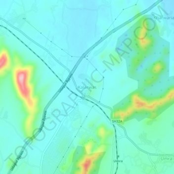
Name: Kalarwas topographic map, elevation, terrain.
Location: Kalarwas, Girwa Tehsil, Udaipur District, Rajasthan, India (24.51893 73.74442 24.55893 73.78442)
Average elevation: 1,913 ft
Minimum elevation: 1,791 ft
Maximum elevation: 2,461 ft
Other topographic maps
Click on a map to view its topography, its elevation and its terrain.
Udaipur
India > Rajasthan > Girwa Tehsil
Udaipur, Girwa Tehsil, Udaipur District, Rajasthan, 313001, India
Average elevation: 2,152 ft
Pratap Park
India > Rajasthan > Girwa Tehsil > Udaipur
Pratap Park, Udaipur, Girwa Tehsil, Udaipur District, Rajasthan, 313001, India
Average elevation: 1,995 ft
Kodiyat
India > Rajasthan > Girwa Tehsil
Kodiyat, Girwa Tehsil, Udaipur District, Rajasthan, India
Average elevation: 2,205 ft