
Biskra topographic map
Interactive map
Click on the map to display elevation.
About this map
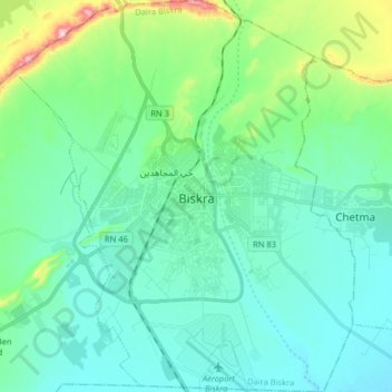
Name: Biskra topographic map, elevation, terrain.
Location: Biskra, Biskra District, Biskra, Algeria (34.78560 5.65367 34.91767 5.79383)
Average elevation: 420 ft
Minimum elevation: 197 ft
Maximum elevation: 1,378 ft
Colonel Carbuccia in charge of this mission was surprised by the topography of the ground and the resistance which opposed him in the middle of a dense vegetation. The struggles and fights continued for 7 months without stopping. It took 7,000 troops and 53 days of blockade for the destruction of the siege by the three colonels together: Canrobert, Barral, and Lourmel giving the death of Chief Bouzian with 1400 besieged and 2130 people on the French side.
Other topographic maps
Click on a map to view its topography, its elevation and its terrain.