
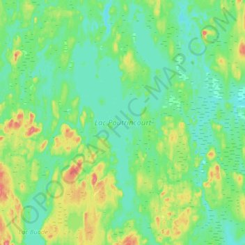
Lac Poutrincourt topographic map
Interactive map
Click on the map to display elevation.
About this map
Name: Lac Poutrincourt topographic map, elevation, terrain.
Average elevation: 1,322 ft
Minimum elevation: 1,270 ft
Maximum elevation: 1,480 ft
Other topographic maps
Click on a map to view its topography, its elevation and its terrain.
Lac aux Épaules
Canada > Québec > Le Domaine-du-Roy > Lac-Ashuapmushuan
Lac aux Épaules, Lac-Ashuapmushuan, Le Domaine-du-Roy, Saguenay–Lac-Saint-Jean, Québec, Canada
Average elevation: 1,699 ft
Lac Priver
Canada > Québec > Le Domaine-du-Roy > Lac-Ashuapmushuan
Lac Priver, Lac-Ashuapmushuan, Le Domaine-du-Roy, Saguenay–Lac-Saint-Jean, Québec, Canada
Average elevation: 1,414 ft
Lac Chanceux
Canada > Québec > Le Domaine-du-Roy > Lac-Ashuapmushuan
Lac Chanceux, Lac-Ashuapmushuan, Le Domaine-du-Roy, Saguenay–Lac-Saint-Jean, Québec, Canada
Average elevation: 1,929 ft
Lac Jonsac
Canada > Québec > Le Domaine-du-Roy > Lac-Ashuapmushuan
Lac Jonsac, Lac-Ashuapmushuan, Le Domaine-du-Roy, Saguenay–Lac-Saint-Jean, Québec, Canada
Average elevation: 1,516 ft
Lac Mervent
Canada > Québec > Le Domaine-du-Roy > Lac-Ashuapmushuan
Lac Mervent, Lac-Ashuapmushuan, Le Domaine-du-Roy, Saguenay–Lac-Saint-Jean, Québec, Canada
Average elevation: 1,388 ft