
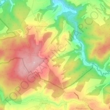
Senscheid topographic map
Interactive map
Click on the map to display elevation.
About this map
Name: Senscheid topographic map, elevation, terrain.
Average elevation: 1,490 ft
Minimum elevation: 1,142 ft
Maximum elevation: 1,772 ft
Other topographic maps
Click on a map to view its topography, its elevation and its terrain.
Eifel
Duitsland > Rijnland-Palts > Landkreis Ahrweiler > Adenau
Eifel, Adenau, Landkreis Ahrweiler, Rijnland-Palts, Duitsland
Average elevation: 1,919 ft
Antweiler
Duitsland > Rijnland-Palts > Landkreis Ahrweiler
Antweiler, Adenau, Landkreis Ahrweiler, Rijnland-Palts, Duitsland
Average elevation: 1,280 ft
Nürburg
Duitsland > Rijnland-Palts > Landkreis Ahrweiler
Nürburg, Adenau, Landkreis Ahrweiler, Rijnland-Palts, Duitsland
Average elevation: 1,837 ft
Remagen
Duitsland > Rijnland-Palts > Landkreis Ahrweiler
Remagen, Landkreis Ahrweiler, Rijnland-Palts, 53179, Duitsland, Rodderberg
Average elevation: 367 ft
Ohlenhard
Duitsland > Rijnland-Palts > Landkreis Ahrweiler
Ohlenhard, Adenau, Landkreis Ahrweiler, Rijnland-Palts, Duitsland
Average elevation: 1,506 ft
Meuspath
Duitsland > Rijnland-Palts > Landkreis Ahrweiler
Meuspath, Adenau, Landkreis Ahrweiler, Rijnland-Palts, Duitsland
Average elevation: 1,765 ft
Laacher See
Duitsland > Rijnland-Palts > Landkreis Ahrweiler > Glees
Laacher See, Glees, Brohltal, Landkreis Ahrweiler, Rijnland-Palts, Duitsland
Average elevation: 1,030 ft
Herschbroich
Duitsland > Rijnland-Palts > Landkreis Ahrweiler > Herschbroich
Herschbroich, Adenau, Landkreis Ahrweiler, Rijnland-Palts, Duitsland
Average elevation: 1,572 ft
Wimbach
Duitsland > Rijnland-Palts > Landkreis Ahrweiler
Wimbach, Adenau, Landkreis Ahrweiler, Rijnland-Palts, Duitsland
Average elevation: 1,496 ft