
Billingham topographic map
Interactive map
Click on the map to display elevation.
About this map
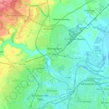
Name: Billingham topographic map, elevation, terrain.
Average elevation: 69 ft
Minimum elevation: -26 ft
Maximum elevation: 279 ft
Other topographic maps
Click on a map to view its topography, its elevation and its terrain.
Stockton-on-Tees
United Kingdom > England > Stockton-on-Tees
Stockton-on-Tees, Tees Valley, England, United Kingdom
Average elevation: 62 ft
Yarm
United Kingdom > England > Stockton-on-Tees
Yarm, Stockton-on-Tees, Tees Valley, England, United Kingdom
Average elevation: 95 ft
Stockton-on-Tees
United Kingdom > England > Stockton-on-Tees > Stockton-on-Tees
Stockton-on-Tees, North East England, England, United Kingdom
Average elevation: 56 ft